
Infographics
-
Phase 1 results
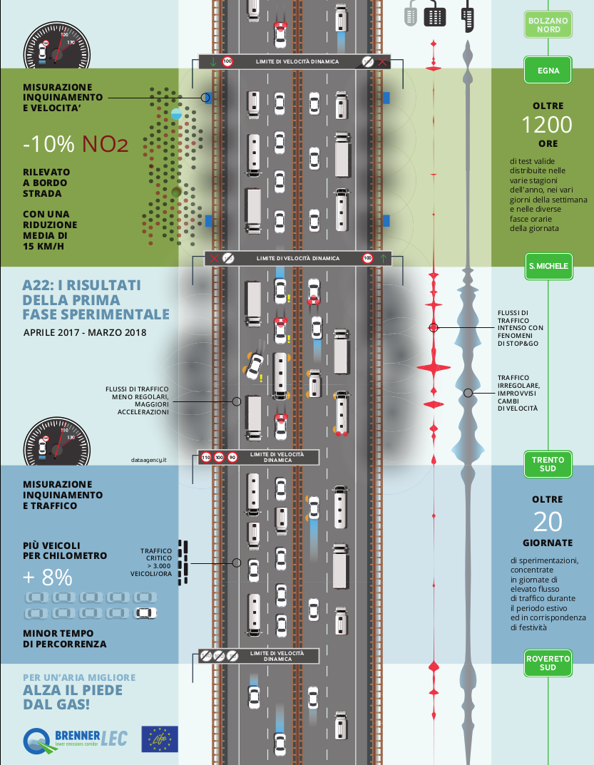
From an environmental point of view the first empirical measurements have highlighted that an average reduction of 15 [km/h] of the average speed of light vehicles, compared with the normal flow of traffic with speed limit at 130 [km/h], determines a reduction of 10% of the average concentration of NO2 (nitrogen dioxide) at the roadside of the highway.
From a traffic point of view, in nearly saturated conditions, the application of variable speed limits (VSL) has determined an increase of the capacity of the highway. More specifically, under these conditions it has been empirically estimated an increase of 8% of the number of vehicles passed through the test stretch. Compared to standard conditions, VSL have confirmed to determine a better traffic fluidity, determining therefore a reduction of the traffic jams, of the stop&go situations and of the travel times.
-
Circulating Fleet on the A22 highway

The infographic presents the most significant results of an in-depth study on the vehicular circulating fleet traveling on the A22, which has been precisely estimated through a detailed analysis of the transits in correspondence of all highway toll booths during certain day type (e.g. working days without tourists and holidays with tourists). The study has put in evidence that the circulating fleet on the A22 is significantly newer than the national average, with a component of EURO 6 vehicles which is already more than the 25% (the national average is about 5%). The amount of heavy traffic is about 28% during working days, while foreign traffic is about the 40% of the whole traffic during summer holidays. From an environmental point of view, the potential benefit deriving from a newer circulating fleet is hindered by a massive presence of diesel vehicles, which is about the 76% of the entire circulating fleet (the national average of registered vehicles is about 52%). The analysis is completed by a qualitative representation of the average distribution of speeds as a function of the vehicles’ types.
-
Emissions of the A22 highway traffic
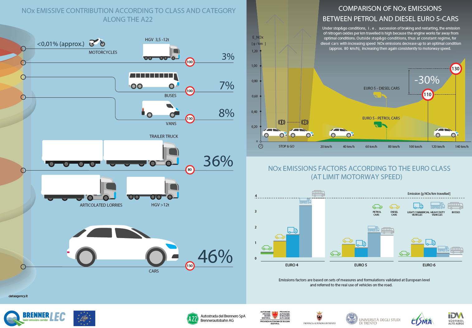
The infographic provides some data in relation to the emissions generated by the different type of vehicles travelling on the A22, which are derived from a study on the circulating fleet on the highway. The focus is on the emissions of the nitrogen oxides (NOx), which are responsible of the concentrations of nitrogen dioxide (NO2); a pollutant that from an air quality perspective is of major relevance in Trentino South Tyrol. This data have been obtained by applying specific emissions factors for each type of vehicle. The emissions factors which are available at the state of the art are based on a set of measurements and formulations that are validated at a European level and are referred to the effective usage of these vehicles on the road. The infographic highlights, as an example, the emissions factors for NOx for different types of vehicles and engines: from the EURO 6 onwards the technology of diesel applied onto heavy vehicles has registered a significant improvement that has allowed to obtain a remarkable reduction of the emissions and the related emissions factors; this improvement has unfortunately not been applied to diesel light vehicles, too. In total, light vehicles are responsible for almost the half of the whole NOx emissions produced by the highway traffic (about the 46%). The behaviour of a recent diesel vehicle (from EURO 4 onwards) as a function of the speed is very different with respect to the behaviour of a gasoline vehicle: not only emission factors are much higher, but also remarkable differences can be noticed in correspondence to the different speeds. When speed increases, emission factors decrease since an optimal condition (around 80 km/h), and then significantly increase again in correspondence to the typical highway speeds. For example, a EURO 5 diesel car travelling at 130 km/h emits about the 30% more if compared to a travelling speed of 100 km/h. It is to underline that in stop&go conditions, i.e. in conditions of repeated start and stops, the emission of NOx for each travelled kilometre is very high because the engine does not work in ideal conditions.
-
Future management of highway traffic
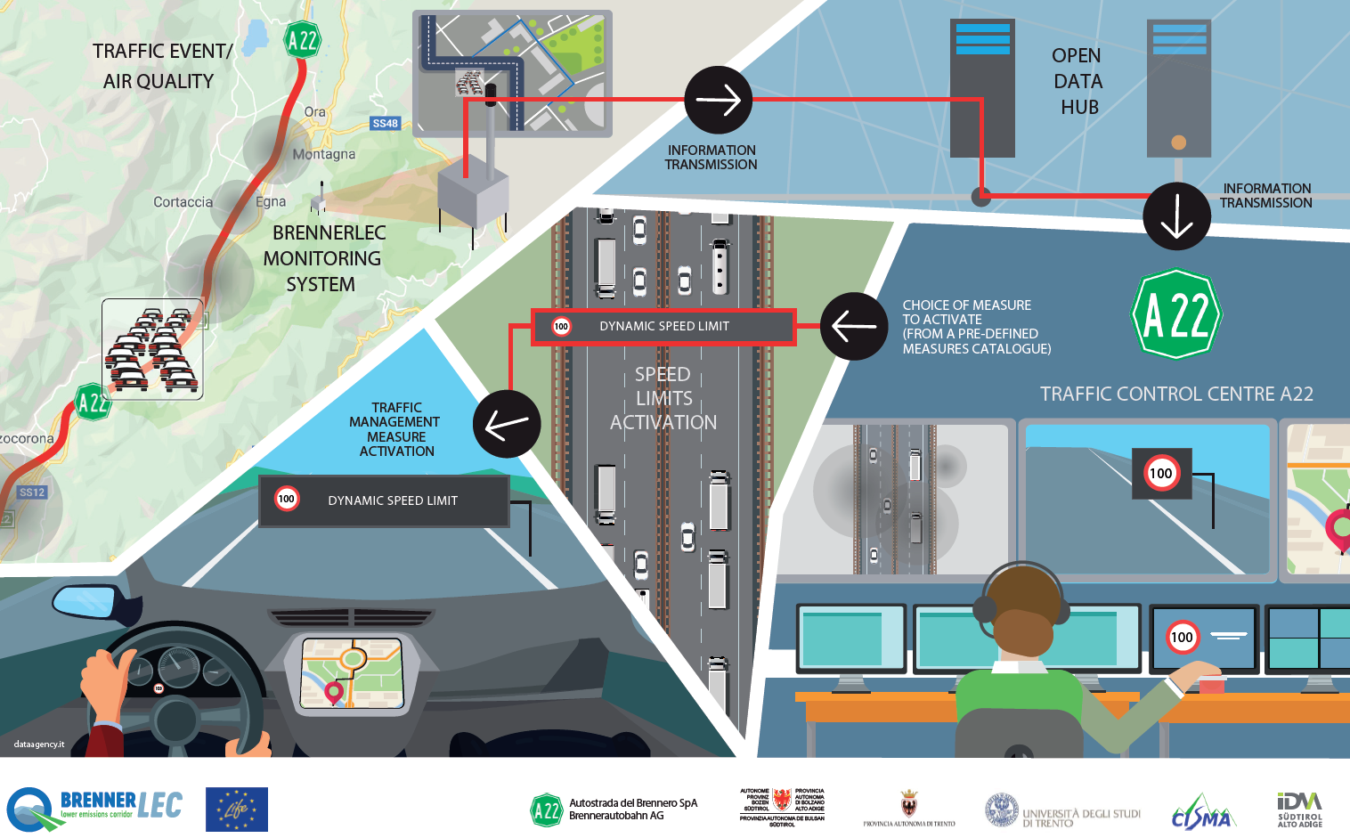
The infographic presents the future modalities of highway traffic management. Through the measurement systems installed along the highway it will be possible for the A22 traffic management centre (Centro Assistenza Utenti CAU) not only to be informed in real-time on a determined traffic event (e.g. traffic jam due to intense traffic flows), but also to be aware of a particularly critical air quality situation (e.g. exceeding of certain reference thresholds of NO2 concentrations). The centre will therefore be able to promptly manage such situations by activating new dynamic and precodified measures under the supervision of the operators of the control room. In particular, a dynamic speed limit can be applied in the different road stretches in order to reduce the emissions generated by traffic and increase the stability of transiting flows. The system will be able to operate also proactively, so to anticipate, when possible, the verification of certain events and activate these measures earlier, thus increasing the efficiency of the implemented measure.
-
Future integrated highway- cities management
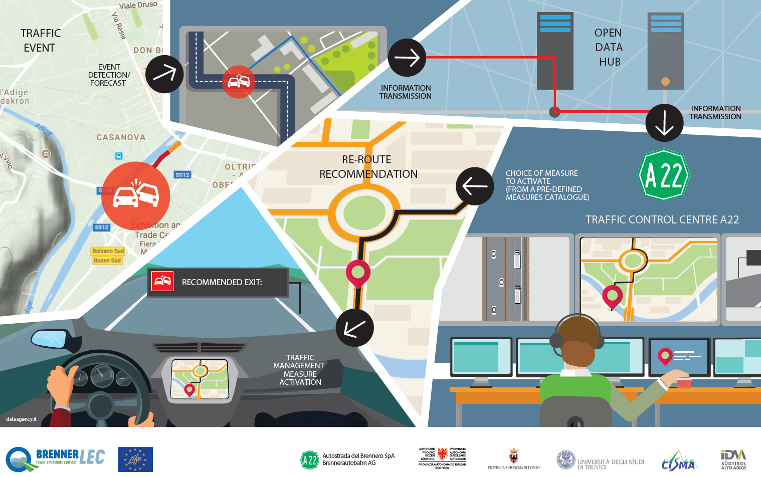
The infographic presents one of the future scenarios of integrated traffic management between the highway and cities that the project aims to implement. In case of traffic event in the urban area (e.g. accident), the urban traffic management centre shares the information of the event to the A22 traffic management centre (Centro Assistenza Utenti CAU). This information sharing workflow is technologically enabled by the Open Data Hub managed by IDM, which has the function to create interfaces with the various systems which are present at a local level and distribute the relevant information to all interested parties. According to codified procedures (and in absence of other concomitant events on the highway), the highway operator can reduce the negative externalities caused by this event by activating proper messages on his own variable message signs (and more generally on all his traveller information services), suggesting for example to the drivers exiting from the highway and entering the city to follow an alternative route in order to reach the desired destination.
-
BrennerLEC monitoring system
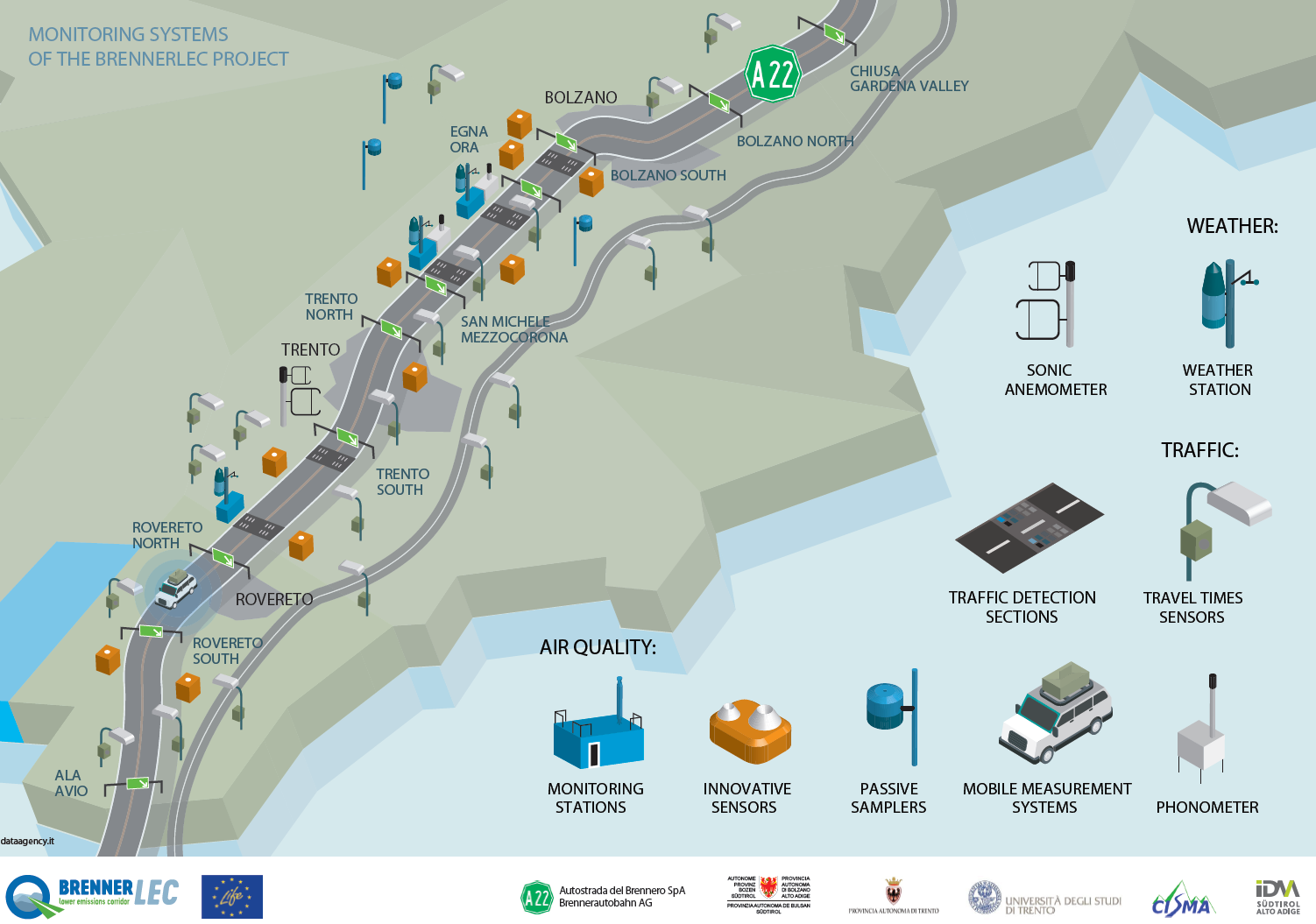
The infographic presents the monitoring system implemented for the project from a qualitative point of view. The domains are basically three: meteorology, traffic and environment. The meteorological conditions, which are necessary to precisely predict the dispersion of the air pollutants, are measured by means of traditional meteorological stations and a sonic anemometer (which is able to evaluate the turbulence effects generated by the highway traffic). Traffic monitoring is performed with traditional detections systems based on inductive loops, which are complemented by more recent techniques for the measurement of the travel times on road sections. Travel times are measured both on the highway as well on the alternative regional network, based on an anonymous scanning of Telepass and Bluetooth devices installed on board of the vehicles. Environmental conditions (air quality and noise) are measured by means of conventional instruments installed in the monitoring stations managed by the Environmental Agencies of the Provinces of Trento and Bolzano, as well as by instruments based on non-conventional technologies. Air quality monitoring is one of the aspects of the project that has the greatest scientific relevancy: not only the measurement of air pollutants which are still little investigated in the literature are monitored (e.g. black carbon), but also a comparative and broad comparison with low cost sensors is foreseen. These sensors are planned in the future to be used for a more distributed monitoring along the highway. Passive samplers are also of particular interest, since they can measure the average of the NO2 concentrations referred to periods of exposure equal to 15 days at different distances of the highway. Black carbon and particle counters are also used in order to better understand the emissions generated by traffic. Finally, a mobile measurement system is used in order to collect further data to be used for calibrating the models of dispersion of the pollutants.
-
Innovative air quality sensor
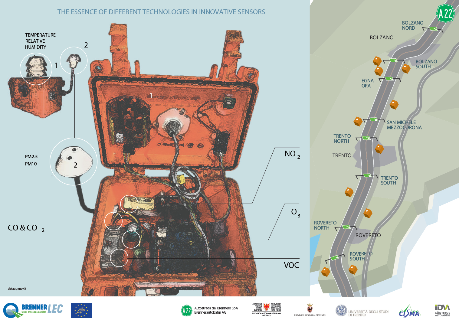
The infographic presents a particularly innovative aspect of the continuous monitoring system of air quality, i.e. a spatially distributed network of low costs sensors supplied by the Institute of Biometeorology of the National Research Council. The acquisition unit is in its turn a measurement station that is able to detect both meteorological (temperature and relative humidity) and air quality parameters. The measured pollutants are more specifically the nitrogen dioxides, the carbon monoxide, the ozone, the particulate matters and the volatile organic compounds. In the project, specific attention is put on the measurement of the nitrogen oxides, which is performed with both electrochimic as well as resistive sensors. Thanks to a controlled acquisition system and advanced post-processing algorithms of the collected data the objective is to have at disposal continuous and adequate measurements that are useful for the application goals of the project.